CHAPTER II
PRE-WAR JAPANESE ESPIONAGE AND INTELLIGENCE
1940-1941
Japan's strategic planning of its war operations was based upon intelligence gathered by the armed services and their overseas agents over a considerable period of time preceding the outbreak of hostilities. When the Japanese forces struck on 8 December 1941, they possessed a fairly accurate knowledge of ground, air, and naval strength in the areas attacked, of the locations of airfields and fortifications, and of the terrain and climatic conditions under which they would have to fight. As the operations progressed, gaps inevitably became apparent in Japanese intelligence, but these were not serious in the first phase of hostilities.1
Examples of the type of information gathered and available to Imperial General Headquarters for the planning of the initial operations are the original intelligence maps reproduced in Plate Nos. 4 and 5. The sketch map showing the dispositions and strengths of American, British, and Dutch Air forces in the Philippines and Southern area (Plate No. 4) was issued on 6 December 1941 by Army Air Defense Headquarters at Keelung, Formosa. It bears the notation that the map was compiled "before the crisis" and that the air strengths indicated were "estimated currently to be undergoing marked reinforcement." The map reproduced in Plate No. 5 contains detailed order of battle information on Australian ground forces as of July 1940.
Similar maps showing troop dispositions and strengths, airfields, and other military installations on the islands of Java and Sumatra were compiled prior to the war and used in the planning of Southern Army operations. (Plate No. 6)
Augmentations of British troop strength in the Malaya, Singapore, and Burma-Thailand border areas in the months prior to the outbreak of war were noted in a "Simplified Table Showing Changes in the Southern Situation Since August 1941", issued by 20th Division Headquarters. Extracts containing intelligence apparently derived from confidential Japanese sources follow:
(From Chief of Staff Report, mid-September 1941) Strength on the Burma-Thailand border is approximately 50,000. In Burma there are an additional 2,000 to 3,000 Volunteer Army troops.
(From Chief of Staff Report, end October 1941) Increase in strength in Malaya is presumed to be 10,000 Australian troops. Strength at Singapore in mid-August was approximately 5,000 Australians. Although information is lacking on numbers, transports carrying Australian reinforcements had reached Singapore by the end of August. The regular Army strength o f 48,000 has reached approximately 60,000. If a rough estimate of the
[21]
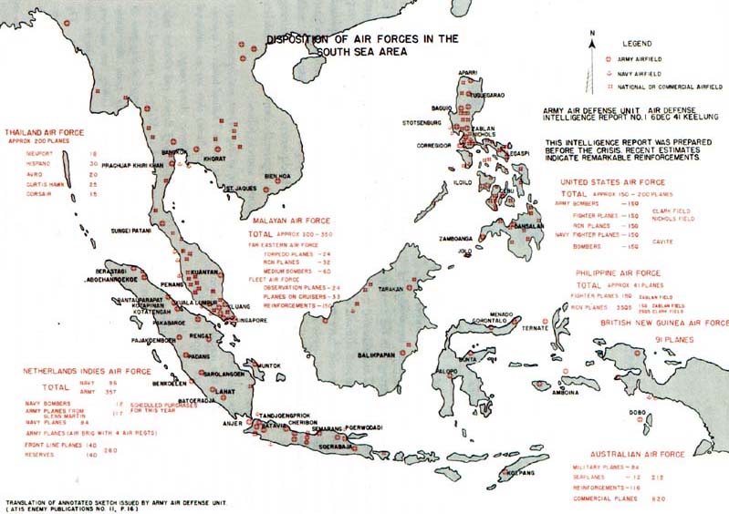
PLATE NO. 4
Disposition of Air Forces in South Sea Area
[22]
increase in Hindu troops is included (increase not according to confirmed intelligence), total strength does not exceed the estimate of 70,000-75,000 by the Singapore Foreign Affairs at the end of August.2
The Army General Staff was also in possession of extensive intelligence concerning the defenses of the Philippines. A compilation of reports entitled, "Situation of Both Sides Prior to the Outbreak of War", covering the period from July to December 1941, contained estimates of American and Filipino troop and air strength as follows:3
The strength of the American Garrison Army in the Philippines was 12,000 (American about 5,500; native about 6,500). Because of the international situation, however, this number was increased by about 5,20O Americans and 6,000 natives, so that by July of this year, the total reached 22,000. The Filipino National Guard and patrol scouts were included under General MacArthur, the American Far Eastern Army Commander, who was to undertake the united command of all troops in the Philippines.
Status of the American Garrison Army:
1. Philippine Division:
24th Infantry Brigade was not in operation in peacetime, but its Headquarters was established at Santiago about July 1941.
2. 94th Tank Battalion (American) was newly organized at Fort Stotsenberg.
3. The strength of the Air Force has increased successively as follows:
Army
| 24th Pursuit Regiment | P-35 |
| 3d Pursuit Squadron | P-36 |
| 17th Pursuit Squadron | P-38 |
| 20th Pursuit Squadron | P-40 |
| 24th Pursuit Squadron | 27 planes at Nichols Field above types included. |
| 19th Bomber Regiment | |
| 1st Pursuit Squadron | |
| 14th Bomber Squadron | B-17 (12 planes) |
| 28th Bomber Squadron | B-18 (13 planes) |
| 36th Bomber Squadron | (Type of plane unknown) |
| 2d Reconnaissance Squadron | 0-19, 0-46, 0-47, 0-52, (13 Planes) |
| 19th Reconnaissance Squadron |
4. The Philippine Defense Regulations call for development of divisions of 7,600 officers and men. (Referred to on separate sheet.) However, indications are that many divisions are far from complete, and some even lack regimental commanders. Also, the required equipment is not provided, and some infantry regiments are not equipped with infantry guns.
5. Training points in Luzon are as follows:
| Aparri | Laoag | Vigan |
| Vigan | Toridanito | |
| Echague | Tuguegarao |
12th Infantry Regiment is training in Luzon.6. For defense purposes, Luzon is divided into northern and southern districts. Planes reported in Central Luzon are as follows:
| Fighters | 130 |
| Bombers | 30 |
| Navy patrol planes | 20 |
| Total | 180 |
Extensive aerial photo coverage of northern Luzon, including the Lingayen Gulf, Vigan, and Aparri coastal sectors (Plate No. 2), was obtained by Imperial General Headquarters a year before the outbreak of war. Commercial planes of the Nippon Airways, manned by military pilots and observers, flew seven photographic missions over Luzon between 27 November and 15 December 1940, ranging as far south as Lingayen Gulf on the west coast and Baler Bay on the east. Lamon Bay, where the Japanese 16th Division landed in the invasion operations, and Bataan Peninsula were not covered by these missions. Flights were made at an altitude of over 21,000 feet and, except at the southernmost point, beyond range
[23]
of detection by defense installations at Clark Field.4
Detailed reports by military intelligence agents who toured the southern areas prior to the war were also in the hands of the Army planning staffs. One such report, made by Major Tetsuo Toyofuku5 on the basis of personal observation in March 1941, covered British New Guinea and was used as the basis of an intelligence study on this area compiled by the Army General Staff. The study was reproduced by General Headquarters, Southern Army, in 1942 for use in the New Guinea operations. Text of the study, entitled "Military Data on British New Guinea," follows:
Part I-Military Value of British New Guinea and Solomon Islands:
These possessions, together with the Dutch East Indies Archipelago, form a natural barrier intersecting the Pacific Ocean from north to south. The northern end is within the radius of action of our bombers from most of our South Sea Mandated Islands, and the southern end is within the radius of action of bombers from the northern part of Australia. (It is approximately 1000 kilometers from Truk and Ponape Islands in our South Sea Mandate, to Rabaul, capital of the Australian Mandated Territory; approximately 1250 kilometers from Cooktown, North Australia, to Rabaul, and approximately 600 kilometers to Port Moresby.) They are separated from the Australian Continent by the narrow Torres Strait. Consequently, possession of this territory would make it easy to obtain command of the air and sea in the Southwest Pacific and to acquire "stepping stone" bases for operations against Australia. Control of the southern coast of New Guinea, in particular control of Torres Strait, would cut communications between the South Pacific Ocean and Dutch East Indies as well as the Indian Ocean Area, and would force the enemy fleet to detour to the southern coast of Australia.
Part II-Observations on Landing Operations in British New Guinea
The area of the Bismarck Archipelago is approximately 50,000 square kilometers and corresponds to the combined area of our Formosa and Shikoku. However, the population of these territories (New Guinea and Bismarcks) is approximately 850,000 natives, most of whom live in the coastal regions.
Nowhere are these territories as yet developed.
Since the greater part is uninhabited, the communications facilities naturally are poor, and even the roads are like the government roads of Australiancontrolled New Guinea, whose total length is only 136 miles (approximately 218 kilometers) of which 109 miles is in the Central Province, 16 miles in the Eastern Province, and 11 miles in Southeastern Province. It is recognized that these roads only connect the villages in the vicinity of the coast.
In regard to present military preparations, it appears that there are small forces and installations in the important political and transportation centers such as Rabaul, Port Moresby, etc. The other sections of the territory are not defended at all.
Landing operations on these various islands can, therefore, be carried out easily at any place where it is possible to land. However, advance and occupation from the captured points by land would be extremely difficult and practically impossible in view of the undeveloped road system and the difficulty of supply. Therefore, even if a point is occupied, it will only secure the vicinity of that point, and occupation of the whole territory will be difficult unless the enemy's fighting spirit is completely demoralized.
It would be advisable to attempt landing operations at Rabaul, Lae (capital of the Australian Mandated Territory), and Port Moresby (capital of
[24]
Australian controlled New Guinea), which are points of military, political, economic, and communications importance. Considering the weakness of the enemy's present defenses and the strength that will be sent to this area by the Australians in the future, great strength will not be required. There are dwellings in these cities, but commodities, especially food and drinking water, are scarce, and self-sufficiency for a long period would be difficult. Our necessities, especially rice, bean paste (miso), and soy sauce, are not stored at all, so there is no other way but to depend on supply from the rear. The difficulty of supply from the rear must be recognized, and it will be necessary to carry large quantities. . . .
Landing Operations at Port Moresby:
(1) General Condition of Harbor and City:
Port Moresby has a good, wide harbor, and the bay is entered by passing between Hanudamava Island (at the mouth of the harbor) and Bogirohodobi Point, approximately 1.5 miles to the east. At the beginning of 1940 there were approximately 800 Europeans, approximately 20 Chinese, and no Japanese residents. The natives (approximately 2000) have built their village over the water and live apart from the white residents. The city is situated between Tuaguba Hill and Ela Hill on the eastern shore of the harbor, and is the center of the government, military affairs, economics, transportation, communications, etc. of Australian-controlled New Guinea. There are various offices, including government offices and branch offices, a radio station, a government-managed electric power plant, church, school, European and native hospitals, an ice plant, bank, hotels, etc.
(2) Value of Port Moresby as a Naval Base:
Although the harbor is rather small for a fleet base, it is fairly deep (maximum 10 fathoms), and the bottom is alluvial soil, and one or two squadrons could anchor without difficulty. A space between the coral reefs outside of the harbor offers a very wide anchoring place, large enough for a large fleet to anchor. However, installations for repairs and supply have not been fully established, so it is valuable only as a port of call.
(3) Military Preparations:
Information obtained by observation of the actual area follows:
(a) Garrison Strength:
Army:
There is a barracks at Granville East (approximately 1 kilometer northeast of the city), which, judging from its size and the amount of equipment, can accommodate approximately 1,000 men. The present garrison appears to be composed wholly of infantry troops, without artillery.Others:
A Royal Australian Artillery Detachment (2 Officers, 38 non-commissioned officers, and privates, who arrived with 6-inch guns) apparently is stationed on Ela Hill and will be reinforced, judging from the fact that the number of barracks on the hill is being increased.Navy:
The strength is not known but appears to be about 30 men. The orderly room is located at the side of the government pier. The station ship has not been identified; only 2 or 3 launches have been identified.(b) Installations:
A road for military use has been built to the top of Ela Hill, and two 6-inch guns are placed on top of this hill. The main line of fire of these guns apparently is directed toward Basilisk Passage. The guns are exposed on top of the hill. According to information, they will be increased by two more guns. In addition to the Kila Kila airfield, approximately 4 kilometers east of Port Moresby, an airfield for military use, approximately 11 kilometers from Port Moresby (location unknown), is expected to be constructed. A single road parallel to the coastal highway, and halfway up the hill of Tuaguba, is being constructed.
(4) Passage of channels:
The greatest difficulty in a landing operation at Port Moresby would be passing through the waterways. There are three channels entering the harbor of Port Moresby. Liljeblad Passage, on the extreme west, has a very strong current and shoals. This passage cannot be used in general because there are shallows before the mouth of the harbor. Therefore, it is difficult to enter this passage. Basilisk Passage, in the center, is
[25]
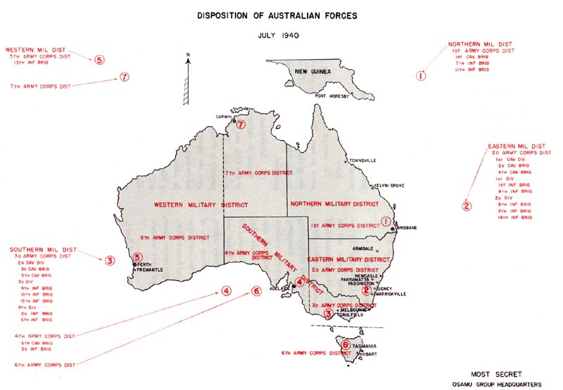
PLATE NO. 5
Disposition of Australian Forces, July 1940
[26]
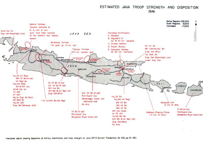
PLATE NO. 6
Japanese Estimates of Java Troop Strength and Disposition 1941
[27]
the channel used by vessels at present, but it is about 6 kilometers from the gun emplacement on Ela Hill and thus is within the guns' effective range. In general, unless the gun emplacement is destroyed, it would be difficult to enter through this channel. Padana Nahua, at the extreme east, is quite wide (about 900 meters and is outside the effective range of the gun emplacement (about 18,000 meters). This channel should be selected for an entrance. However, all three waterways are neither very deep nor wide, and could easily be covered with mines and other obstacles. These obstacles must be cleared first of all. If a place where the Nateara and Sinavi coral reefs can be passed over with boats could be found, then an approach could be made without risking the danger of passing through the channel. Anchoring outside a coral reef is very difficult, so in such a case the transfer to boats would have to be made while drifting.
Fresh water:
This area, in general, consists of barren mountains and is dry for the period of eight months between June and January each year. The rainfall is very small. The residents who depend on rainfall sometimes have to transport water from other areas in order to maintain their means of living. The Government has constructed water storage tanks with galvanized iron roofs for use during droughts, at a place 137 meters above sea level southwest of Tuaguba Hill, in back of the city, and this water storage is used in emergencies. Their capacity is said to be several tens of thousands of tons, but this is not definite. The problem of drinking water is most urgent in this area, and the extension of a water supply line is especially important in planning the establishment of a harbor. According to rumor it is planned to bring the water down from the Laloki River, and arrangements for this will be completed about August of this year.Fuel:
It is said that 5,000 drums of gasoline, 3,000 drums of heavy oil, a large quantity of motor oil etc., are stored in Carpenter's Warehouse. The nature of the gasoline used for airplanes is not known.Automobiles:
For military use-about 50.
For civilian use-about 200 (no busses).Part III-Value of Bismarck Islands and British New Guinea as air bases in case of war with Britain and America:
1. Essentials:
As explained in Part I, the Bismarck Islands are within the radius of action of bombers operating from most of our South Sea Mandated Islands. In turn, Torres Strait and the northern part of Australia are within aerial domination from the Bismarck Islands and British New Guinea, and this territory, in general, is judged to possess an important value from the standpoint of air operations in a war against Britain and America. In particular, if air superiority over Torres Strait is gained, it is thought that it would be advantageous in cutting off enemy communication between the Pacific Ocean and Dutch East Indies, as well as the Indian Ocean.
In regard to the possession of airfields in this area, the first principle is to use established airfields, and if necessary to construct new ones on farmland in flat areas.
The established airfields are not wholly adequate to fulfill military requirements, but some of them can be utilized immediately and can be extended with a small expenditure of labor.
As fuel is difficult to obtain in this area, in general it must be supplied from the rear. Much of the equipment for repairs and construction is inadequate.
The condition of the established airfields, landing fields and air network at present in British New Guinea is as shown in Appendix Map No. 10. (Map not attached)
2. Value of Bismarck Islands and their vicinity (Appended Map No. 6, Reference No. 6) [Not attached]
(I) Essentials:
The established airfields in the Bismarck Islands and their vicinity are two landing fields at Rabaul and Vunakanau, and it is planned to construct others at Kavieng (northeastern end of New Ireland) Namatanai, Buka Passage (the strait separating Bougainville and Buka Islands in the Solomons, and Kieta (the capital of Bougainville). Only one place in the harbor of Rabaul is used for seaplanes, but another is located at Kileg on Galawa Island, across the Lolobo
[28]
(northeastern coast of New Britain). While the situation regarding aviation gasoline is not known, apparently almost none at all is stored. Planes operating on a regular schedule apparently refuel at Salamaua or Moresby on the return trip. There are no reports of aviation gasoline being supplied at Rabaul.
3. Value of Island of New Guinea:
(1) Essentials:
There are airfields and landing fields on the Island of New Guinea. Most of them are concentrated in Morobe Province because they are used by planes that transport gold from mines developed in the province. The airfields used mainly by land-planes are at Salamaua, Lae, Wau, Madang, Wewak, Port Moresby, etc. Salamaua and Wau are the only two airfields on which we have definite information at present. To discuss the value of the airfields in British New Guinea from the above data is futile. However, since these (the two airfields at Salamaua and Wau) are typical of those used by the regular air lines, I believe they are sound references for use in estimating the others. It seems that the only specially-constructed seaplane base is at Port Moresby.6
The lengthy background of Japanese espionage and subversive activity in the Netherlands East Indies is attested by the following passage from an article entitled, "New Life of the People of Sumatra":
It was the Achin People who fought against Holland and very bravely defended their independence to the end. The Achin People are naturally fearless. Their native place is on the northern edge of Sumatra; in area it is one and a half times the size of Formosa, and it has the sea on three sides. Again, there are many mountains and geographical factors. Due to these, the natives were able to resist fiercely for 40 years following 1873. Controlled by one family, these warriors hid in the woods and often conducted violent guerrilla warfare, harassing the Dutch troops. The last ten years it was a chronicle of chivalry that the Japanese youth, Motohiko Ban, struggled hard to assist the young tribal chief, Pannamu. However, in 1922, Ban was recalled to Japan by the Foreign Office, and the Achin finally broke up their swords and submitted.7
An insight into more recent phases of possible Japanese espionage in the Netherlands East Indies is provided by the following excerpt from an account of the Japanese operation against Java written by an unnamed staff officer, a lieutenant colonel, and published in the Osaka Mainichi:
It was dark when we arrived at Bandoeng. Late that night, I went into a room of the old Homan Hotel, where I stayed over two years ago....
For the purpose of meeting the Army Commander in the afternoon, I went to the Ifura Hotel, north of Bandoeng. I asked for the old room which I took the year before last.8
[29]
Go to: |
|
Return to the Table of Contents
 |
|
Last updated 1 November 2006 |